Filter: Categories of Wisconsin Historical Images
Filter: FULL_DATE of 1778
Filter: Categories of Wisconsin Historical Images
Filter: FULL_DATE of 1778

| Date: | 1778 |
|---|---|
| Description: | Hand-colored. London, 1778. Coordinates: W 99⁰--W 83⁰/N 49⁰--N 41⁰. Scale [ca. 1:3,500,000] |

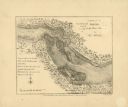
| Date: | 1778 |
|---|---|
| Description: | This Italian map from 1778 depicts the upper portion of the Old Northwest. Rivers and lakes are identified and relief, real and imagined, is depicted picto... |

| Date: | 1778 |
|---|---|
| Description: | Map of European claims in North America, with France shown as having claim to the most land, and the British colonies confined to east of the Appalacian Mo... |

| Date: | 1778 |
|---|---|
| Description: | Detailed map of the Chesapeake Bay region and surrounding states. It shows a detailed account of the borders, cities, towns, islands, swamps, mountains, ri... |

| Date: | 1778 |
|---|---|
| Description: | Map of the land between Fort Ticonderoga and Albany. It shows cities, forts, mills, roads, mountains, swamps, waterfalls, lakes, and rivers. A few annotati... |
If you didn't find the material you searched for, our Library Reference Staff can help.
Call our reference desk at 608-264-6535 or email us at: